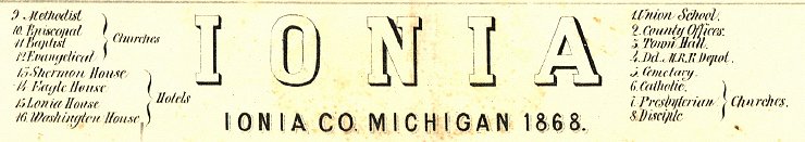
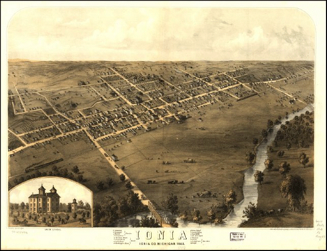
1868 Map

1868 Map of Ionia, Michigan Drawn by A.Rugers
Library of Congress Map

     This is a map of Ionia, Michigan as it was in 1868. It is drawn in pencil by one "A. Rugers" of which I know nothing more, other than to say that A. Rugers was an excellent artist. The details in this map are incredible. The complete file for this map is some 176 megabytes making it far too large for any internet use. I have extracted some of the more interesting details of the map as well as for the landmarks numbered on the map itself.

     Below are links to various landmarks the artist numbered on the map, along with a map like the one above with labels indicating the location of the landmark within the town. Enjoy!

Full Map Images
1868 Map of Ionia
Map with Labels showing location of landmarks
Downtown Ionia Village 1868
1886 Street Guide
Churches and Town/County owned Buildings
Presbyterian and Disciple Churches At Main and Washington
Methodist and Episcopal Churchs and the Town Hall
Methodist and Episcopal Churches, the Town Hall, the Baptist Church and the Sherman House Hotel
The Catholic Church
The Evangelical Church near the corner of Pleasant Street and Washington Street
The Union School
Hotels
The Washington House Hotel Near Dye Street
The Ionia House Hotel
The Eagle House Hotel, corner of First and Main
Trains and Depot, Bridges and Buggies
Passenger Train Leaving Town
Dd. M. Railroad Depot near Depot and Front Street
Suspension Bridge Over the River
Cargo train heading out of town near Congress Street
Horse Drawn Buggy in front of Union School
Other Scenes and Landmarks
Bringing in the Hay
The Cemetery


Last update October 18, 2021